Most woodlands and forests both contain and form elements of our historic environment. These may take the form of archaeological features, ancient trees, the woodland itself or indeed the wider landscape in within which the woodland sits.
Grazing can be complimentary to many such features and indeed may have a historic association with them. For example, areas of historic parks, forests or common land may once have had many centuries of grazing, partly resulting in the very nature of the landscape itself. Equally, features such as stock pens are a direct artefact of animal husbandry.
While grazing may not have a direct association with an archaeological feature such as a burial mound, it can still offer an effective method of vegetation control both upon and surrounding it. However, unmanaged grazing can be very detrimental to the historic environment. It is therefore essential to know what historic environment features are present on a site before introducing grazing, to allow informed management.
This section of the grazing toolbox examines some of these potential problems and outlines methods of mitigation.
Ancient trees and woodland
Many wooded landscapes will have been grazed at some point throughout their history and, in most cases, re-establishing livestock within them will provide few problems.
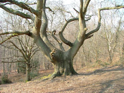
Ancient trees may also take other forms such as lapsed coppice (trees that have been historically coppiced but have not been coppiced, usually for some decades), old, unmanaged trees, or phoenix regeneration (growth of shoots vertically from the trunk of a windthrown tree) and in most cases, grazing is good for these ancient trees, as it impedes the establishment of any other vegetation likely to compete for water or nutrients.
However, concerns could arise if an ancient tree is used as a scratching post or for shelter, as physical damage to the tree or soil erosion around the roots could lead to increased stress for the tree.
N.B.Whilst the natural heritage forms part of the historic environment, only veteran/ancient trees are considered here, as ancient or rare ground flora considered elsewhere within this grazing toolbox.
Grazing on archaeological sites
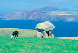 A grazed archeological siteArchaeological sites form a principal component of the historic environment and provid us with a valuable (and irreplaceable) insight into our past. Important sites and must therefore be protected as both a resource for current study and for future generations.
The importance of archaeological conservation is reflected within forestry and other land management policies at both national and international levels. Archaeological features come in a wide variety of shapes and sizes, ranging from the locations of small artefacts (finds) to substantial monuments or field systems. Some legally protected in the form of Scheduled Ancient Monuments (SAMs) or listed buildings.
Damage to these designated features can lead to criminal prosecution. However, given that it is necessary to protect all important archaeological features both designated and non-designated sites will be considered here collectively.
Archaeological features are described below, grouped very broadly by their physical appearance as this characteristic may influence their grazing management.
Earthworks
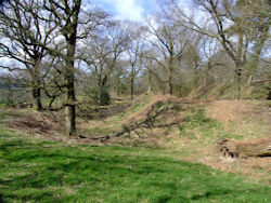
These features are formed either by the removal of natural materials from the ground or by their excavation and adjacent accumulation to form raised or levelled areas.
This category alincludes eroded hollow ways, ancient tracks and roads. With the possible exception of active route-ways, deep mineral excavations or spoil heaps, earthworks are usually covered with soil and surface vegetation. With careful management, most earthworks can usually tolerate grazing.
Standing features
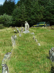
They are unlikely to support any soil or vegetation and therefore will not be subjected to direct grazing pressure. However, they will often occur in grazed landscapes and may be inadvertantly damaged (see risks below).
Surface finds and buried materials
These are often the remnants of domestic or industrial processes and can vary from a few fragments of worked stone to large areas of charcoal or mineral waste.
Providing any vegetation layer is maintained, grazing may be acceptable as the likelihood of artefact movement may be small. By its very nature, buried archaeological evidence will be least at risk from animal grazing. However, this will depend greatly upon the depth of burial, as shallow deposits will inevitably be at greater risk from disturbance by erosion.
For many archaeological sites, a low ground vegetation can have many benefits. This is especially true for earthworks, where plants such as grass helps to lock soil particles together, thereby maintaining the integrity of the feature. Equally, any ground vegetation becomes the surface that is walked upon, thereby further protecting the earthwork from physical disturbance.
For these reasons, archaeological literature often recommends grazing as a management tool as it not only maintains a low vegetation cover (keeping the site visible), but also prevents the establishment of any unwanted woodland. However, there are many reported incidences where grazing on archaeological sites has been identified as a cause of significant damage. Listed below are some key points that should be considered to help protect archaeological sites in grazed environments. These are followed by a selection of specific risks with suggested mitigation measures.
Key considerations
- Understand the site: It is essential to know what historic environment features are present on a site before introducing grazing, to allow informed management. This would often form part of the design, forest or management plan process. Information about a site proposed for grazing can be sought from either the national or local authority historic environment adviser. (See further information for details).
- Past land use: where possible, research the land-use history of a proposed site, as this may be useful in informing the suitability of a site for grazing today.
- Treat individually: assess and manage each site on its own merits using professional input and judgement where necessary.
- Monitor: check sites or features for signs of erosion or damage and, if they occur, manage stock levels or site access accordingly. Where serious erosion is found, seek professional advice regarding any necessary repairs.
Specific risks
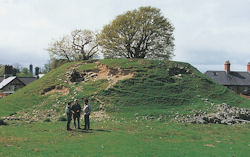 Image showing erosion damage to an archaeological mound. © CADW/Matt RitchieRisk: Overgrazing can lead to a loss of ground vegetation cover, thereby increasing the risk of soil erosion.
Soil erosion is a greater risk to earthworks and surface scatters, however it should generally be avoided on all archaeological sites.
Mitigation measure: Monitor and control stock levels accordingly. Where soils become exposed, remove stock to allow re-establishment of vegetation. Where soils have become eroded, seek professional guidance on suitable methods of repair. Use locally sourced materials and grass seed where repairs are necessary.
Risk: Grazing on soft soils or during prolonged periods of wet weather can increase the likelihood of stock induced soil erosion.
Mitigation measure: Avoid grazing during prolonged wet periods or reduce stoking levels to minimise risk
Risk: Focal points of animal activity such as feeding sites (troughs, ring feeders, hay racks etc), drinking points or mineral supplements should not be located on or near sensitive archaeological sites where they would result in greater localised ground pressure resulting in increased poaching and soil erosion.
Mitigation measure: Avoid placing such items in highly sensitive areas. Where it is felt they can be tolerated, they should be moved on a regular basis to prevent prolonged pressure in any one place.
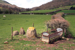 Image showing inappropriate location of fence and feeding trough in close proximity to archaeological features © CADW
Risk: Gates, fences and route-ways should not be located on or near an archaeological site where they would result in areas of increased livestock activity, thereby increasing the risk of soil erosion.
Mitigation measure: Do not place fences on archaeological sites as the insertion of posts may in itself be damaging. Locate stock control points and gates away from monuments and where they do not result in the establishment of potentially damaging animal paths.
Risk: Where earthworks have steep slopes or where other types of archaeological site occur on inclined terrain, there will be an increased risk of erosion.
Mitigation measure: Do not place large animals or maintain high stocking densities on steeply sloping earthworks.
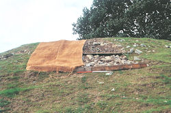 Image showing stages of monument repair. © CADW/Matt Ritchie
Risk: Animal induced soil erosion can occur where inappropriate stock is placed on sensitive soils, where stocking density is too great or where animals actively dig into the soil to create dust baths or in search of nutritional supplements.
Mitigation measure: Ensure that a site’s soil and vegetation cover can support the proposed stock type and density without damage. If scrape or dust baths become established, remove stock and seek advice on monument repair. Consider establishing a similar scrape away from the archaeological remains.
Risk: Where standing features occur, they can be used as scratching posts by grazing stock.
This can lead not only to physical damage of a feature such as a standing stone, but in extreme cases, increased soil erosion at the base of the feature can lead to instability.
Mitigation measure: Monitor such features. If damage is seen to occur, exclude the stock from the area and consult with a local authority archaeologists to agree on long-term management. Erecting a scratching post away from the historic feature may provide respite.
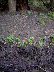
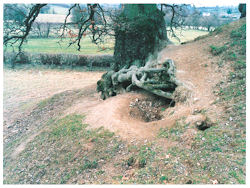 Image showing animal induced erosion at the base of a tree. © CADW
Risk: Where trees are retained on earthworks in a more open landscape, they can act as a focal point for shelter.
This can lead to increased erosion around the base of the trees.
Mitigation measure: When this occurs, seek advice from the local authority archaeologist. The favoured management option is likely to be to exclude stock from the area, but in some circumstances, there may be justification in removing the trees. However, the trees may also have some historic landscape value of their own.
Risk: Selective grazing can result in an archaeological site becoming dominated by an unwanted, less palatable type of vegetation such as bracken.
Mitigation measure: If this occurs, altering the type of animal stocked may solve the problem. Otherwise, manual cutting or rolling of the weed will be required to control it.
Risk: Where grazing is being cosidered on former mineral extraction sites, further information should be sought on the types of substances likely to remain on site and the potential risks to livestock or from any site disturbance that may follow.
Mitigation measure: Consult with former land owner/manager if there is uncertainty over past use and the potential materials remaining on site. If doubt remains, some environmental analysis and consultation should be considered.
Further sources of information
National Monuments Records: These are maintained by national organisations and contain information on many elements in the historic environment. Please note that the national records do not always contain all the information that is contained in local records.
- England : NMR pastscape web
- Scotland : RCAHMS pastmap web
- Wales : RCHAMW COFLEIN web
- Northern Ireland: HERoNI map viewer
Local Sites and Monuments or Historic Environment Records (SMR/HER): Often, but not always maintained by a local authority. An increasing number have online information. Staff may also be able to advise on locally relevant designations, policies, projects and advisory services.
Association of Local Government Archaeological Officers (ALGAO) UK
- England: All County, Unitary and National Park authority’s have some form of archaeological service
- Scotland: Most Scottish local authorities have an archaeological service or have a partnership arrangement with a neighbouring authority
- Wales: Archaeological Trusts maintain SMR/HERS and offer a range of services
Please note that not all the information contained in NMR/SMR/HERS has been validated in the field, indeed many areas have not been the subject of archaeological survey and most records will require interpretation as to how they should influence site management.
- It is inadvisable to prepare management plans based solely on 'the dots on a map' contained in many heritage record systems without having an appreciation of the nature and extent of the features and area to be conserved.
Other sources of information:
- Forests and Historic Environment
- Archaeology Scotland: - Advice, guidance and case studies for farming and rural land managers.
- Online UK national monument record search (UK)
- MAGIC - interactive map service bringing together environmental information from across government.
- Ancient/veteran tree information: Ancient tree forum and Tree register